


ste Roseline

vincente204
User
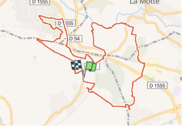

Length
15.4 km

Max alt
190 m

Uphill gradient
261 m
Km-Effort
18.9 km

Min alt
65 m

Downhill gradient
265 m
Boucle
Yes
Creation date :
2025-01-14 07:48:42.522
Updated on :
2025-01-14 13:17:53.174
5h27
Difficulty : Difficult

FREE GPS app for hiking
 SityTrail
IGN / Geographical institutes
SityTrail Plus
The world is yours!
About
Trail Walking of 15.4 km to be discovered at Provence-Alpes-Côte d'Azur, Var, Les Arcs-sur-Argens. This trail is proposed by vincente204.
Description
fácile
Positioning
Country:
France
Region :
Provence-Alpes-Côte d'Azur
Department/Province :
Var
Municipality :
Les Arcs-sur-Argens
Location:
Unknown
Start:(Dec)
Start:(UTM)
298962 ; 4816508 (32T) N.
Comments